Adding O&G Reserves, Pertamina EP and P3GL Carry out Geochemical Survey in Matindok Block
KEMENTERIAN ENERGI DAN SUMBER DAYA MINERAL REPUBLIK INDONESIA
SIARAN PERS
NOMOR: 667.Pers/04/SJI/2019
Tanggal: 19 November 2019
Tambah Cadangan Migas, Pertamina EP dan P3GL Survei Geokimia di Blok Matindok
Pusat Penelitian dan Pengembangan Geologi Kelautan (P3GL) Kementerian ESDM bersama PT Pertamina EP melaksanakan Survei Geokimia Microseapage Area Offshore di Blok Matindok, Sulawesi Tengah yang telah dimulai pertengahan Oktober lalu dan akan dilaksanakan selama 3 bulan, mulai dari persiapan, akuisisi data geofisika dan pengambilan sampel untuk analisis geokimia hingga akhir Desember 2019 nanti.
Survei ini dilatarbelakangi oleh upaya PT Pertamina EP untuk meningkatkan cadangan demi menjamin keberlangsungan industri hulu migas. Salah satu potensi yang besar adalah potensi sumber daya migas di area lepas pantai Matindok, yang meliputi meliputi area prospek Bubalus, Kudukudu dan Kepekepa.
Kegiatan survei ini ditujukan untuk mengantisipasi tingginya risiko pemboran dan biaya tinggi, terkait dugaan keberadaan potensi hidrokarbon di area Pantai Matindok khususnya keberadaan source rock di area lepas pantai Matindok. Selain itu survei dilakukan untuk membuktikan adanya source rock alternatif selain di Batui Trust Kitchen, serta mengurangi resiko operasional pemboran di laut dalam.
Source rock adalah batuan yang kaya zat organik dan jika mengalami cukup pemanasan akan menghasilkan minyak dan gas. Batui Thrusts merupakan jalur deformasi benturan antara mikrokontinen Banggai-Sula dengan East Sulawesi Ophiolite (ESO), yang terjadi sebagai akibat benturan antara mikrokontinen Banggai-Sula dengan Sulawesi Timur.
Lapangan migas Donggi-Matindok memiliki peran penting dalam mendukung produksi gas alam cair atau Liquefied Natural Gas (LNG) Indonesia. PT Pertamina EP Asset 4 mengembangkan lapangan migas Donggi Matindok Field sejak April 2016 lalu. Saat ini lapangan migas tersebut memproduksikan gas dan kondensat dari 2 struktur aktif yaitu Donggi dan Matindok. Lapangan Matindok telah menghasilkan kondensat dan sudah mulai mengirimkan LNG tahun 2017.
Pertamina EP juga perlu melakukan penilaian lanjut terhadap Direct Hydrocarbon Indicators (DHI) di prospek area lepas Pantai Matindok, terutama yang menunjukkan eksistensi indikasi keberadaan hidrokarbon secara langsung. DHI dapat membantu untuk menyimpulkan adanya akumulasi hidrokarbon pada data seismik. Tindakan ini menggunakan pendekatan analisa geokimia terhadap rembesan micro dan macro seepages dalam perencanaan eksplorasi yang lebih tepat.
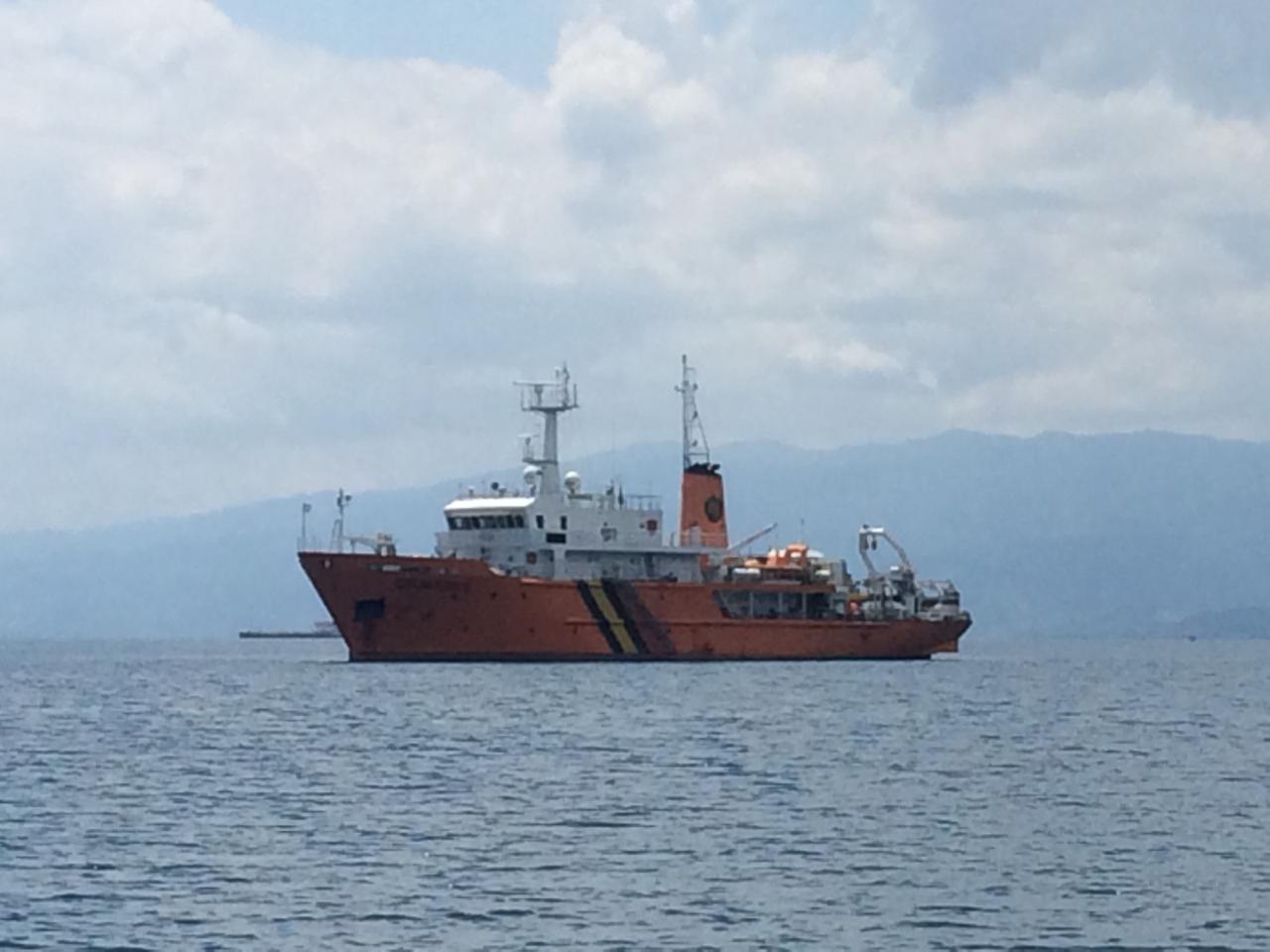
Survei yang dilakukan oleh Puslitbang Geologi Kelautan meliputi area seluas 1.225 km2 dengan kedalaman air rata-rata di atas 500 hingga 1000 meter. Wahana survei yang dipergunakan dalam penelitian ini adalah Kapal Riset Geomarin III dan ditunjang peralatan survey geologi dan geofisika, di antaranya Multibeam Echosounder (MBES), Subbuttom Profiling (SBP), Sidescan Sonar (SSS), serta peralatan Piston Corer, dan dilengkapi dengan Sound Velocity Profile (SVP). Pelaksanaan survei geofisika telah dilaksanakan mulai tanggal 26 Oktober hingga tanggal 7 November 2019, sedangkan survei geologi mulai dilaksanakan tanggal 13 November hingga akhir bulan Desember 2019. (ER/AS/KO)
Kepala Biro Komunikasi, Layanan Informasi Publik dan Kerja Sama
Agung Pribadi (08112213555)MINISTRY OF ENERGY AND MINERAL RESOURCES REPUBLIC OF INDONESIA
PRESS RELEASE
NUMBER: 667.Pers/04/SJI/2019
Date: 19 November 2019
Adding O&G Reserves, Pertamina EP and P3GL Carry out Geochemical Survey in Matindok Block
The R&D Center for Marine Geology (P3GL) of Ministry of EMR together with PT Pertamina EP carry out a geological survey of Microseepage Area Offshore in Matindok Block, Central Sulawesi, for 3 months--from last October to the end of December 2019--with activities comprising preparation, acquisition of geophysical data, and collection of samples for geochemical analysis.
The survey was set off by PT Pertamina EP's intention to increase oil and gas reserves to ensure sustainability of the upstream oil and gas industry. One large potential is located offshore Matindok, covering prospect areas of Bubalus, Kudukudu, and Kepekepa.
The survey is aimed to anticipate the high risk of drilling and the high costs, related to predicted hydrocarbon potential at Matindok Beach area--especially the existence of source rock at offshore Matindok. In addition, the survey is conducted to prove there is alternative source rock other than Batui Thrust Kitchen as well as to reduce the operational risk of deep sea drilling.
Source rock is rocks that are rich in organic substances. When heated, these rocks will produce oil and gas. Batui Thrust is a collision deformation path between Banggai-Sula and East Sulawesi Ophiolite (ESO), formed as the result of the collision between the Banggai-Sula microcontinent and East Sulawesi.
The Donggi-Matindok oil and gas fields play important role in supporting Indonesia's production of Liquefied Natural Gas (LNG). PT Pertamina EP Asset 4 has developed the Donggi-Matindok Fields since April 2016. Currently, the fields produce gas and condensate from 2 active structures, namely Donggi and Matindok. Matindok Field has produced condensate; in fact, LNG shipment from the field started in 2017.
Pertamina EP also needs to make further assessment of Direct Hydrocarbon Indicators (DHI) of the prospect area at offshore Matindok Beach, especially in locations that show direct indication of hydrocarbon. The DHI can help infer hydrocarbon accumulation from seismic data. Conclusion is drawn by using geochemical analysis to the micro and macro seepages to make exploration planning more accurate.
This survey by the P3GL covers an area of 1,225 km2 with average water depth of 500-1000 meters. The research is carried out with Geomarin III Research Vessel and supported by geological and geophysical survey equipment such as Multibeam Echosounder (MBES), Subbuttom Profiling (SBP), Sidescan Sonar (SSS), and Piston Corer, as well as equipped with Sound Velocity Profile (SVP). The geophysical survey was carried out from 26 October to 7 November 2019, while the geological survey is conducted from 13 November until the end of December 2019. (IY)
Head of Bureau of Communication, Public Information Services, and Cooperation
Agung Pribadi (08112213555)
Share This!
Recent News
-

ICP Mei Turun ke USD106,56/Barel Seiring Redanya Ketegangan Geopolitik...
Saturday, 6 June 2026
-

Kementerian ESDM Bongkar Dugaan Tambang Ilegal di Gunung Botak, Maluku
Saturday, 6 June 2026
-

Kementerian ESDM Lantik 745 PNS Baru, Talenta Muda untuk Hadapi Tantan...
Tuesday, 2 June 2026
-

Kementerian ESDM Gelar Apel Hari Lahir Pancasila
Monday, 1 June 2026
-

Teruskan Tradisi Baik, Wamen ESDM Serahkan Daging Kurban
Friday, 29 May 2026
-

PLTS 100 GW, Wamen ESDM: Kita Lakukan Percepatan
Friday, 29 May 2026
ICP Mei Turun ke USD106,56/Barel Seiring Redanya Ketegangan Geopolitik...
Saturday, 6 June 2026
Kementerian ESDM Bongkar Dugaan Tambang Ilegal di Gunung Botak, Maluku
Saturday, 6 June 2026
Kementerian ESDM Lantik 745 PNS Baru, Talenta Muda untuk Hadapi Tantan...
Tuesday, 2 June 2026
Kementerian ESDM Gelar Apel Hari Lahir Pancasila
Monday, 1 June 2026
Teruskan Tradisi Baik, Wamen ESDM Serahkan Daging Kurban
Friday, 29 May 2026